Radar Mile: Definition, Meaning, and Importance in Navigation
Introduction
Radar (Radio Detection and Ranging) systems is an critical equipment for aviation, maritime and Defense and used to provide precise distance measurement. One commonly used unit in these domains is the Radar mile or Radar Nautical Mile. While it may sound like a specialized term, it is closely related to a well-known unit used globally in navigation—the nautical mile.
In this blog post we will break down what a radar mile is, how it works, and why it matters.
What is a Radar Mile?
A radar mile is a unit of distance used in radar systems and is equivalent to a nautical mile.
- 1 Radar Mile = 1 Nautical Mile = 1.852 kilometers (1852 meters)
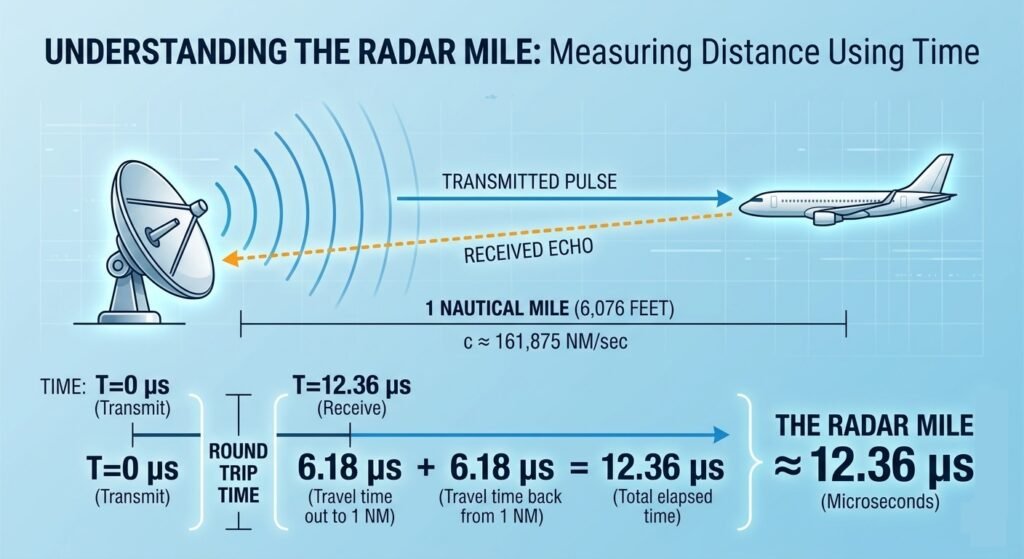
In technical terms, Radar mile is an auxiliary constant for converting time (delay) to the corresponding scale distance on the radar display.
- 1 Radar Mile = 12.36 μ second (Round Trip Delay)
A pulse radar transmits a short burst of electromagnetic energy. The target range is determined by measuring elapsed time, which is while the pulse travels to and returns from the target. Because two-way travel is involved, a total time of 12.36 microseconds per nautical mile will elapse between the start of the pulse from the antenna and its return to the antenna from a target in a range of 1 nautical mile.
Radar Mile unit is widely used in Air Traffic Control (ATC), Marine Navigation Systems and Defense Surveillance Applications
How Radar Mile is Measures Distance
- A radar system transmits a radio signal.
- The signal travels at the speed of light, hits a target, and reflects back.
- The radar calculates the time taken for the round trip.
- Distance is computed using following formula
- Distance = Speed of Light × Time /2
- 1 nautical mile – 1852 nm
- Speed of Light – 300×10^6 meters/ second
- Time = 2x Distance x Speed of light
- Time = 2x 1856 / 300×10^6 = 12.36 μ second
- Distance = Speed of Light × Time /2
Practical Example, If a radar system detects an aircraft at 15 radar miles, the actual distance is:
- 15 × 1.852 = 27.78 km
This helps pilots and operators quickly assess proximity and take necessary actions.
Why We Use Radar Miles Instead of Kilometers?
Following are some of the main pointer using radar miles (nautical miles) instead of Kilometers:
- Global Navigation Standard: Nautical miles are based on Earth’s geometry specifically, one minute of latitude. This makes them ideal for global navigation.
- Aviation Compatibility: Pilots and air traffic controllers use nautical miles to know distance between aircraft, separation standards and flight planning etc.
- Maritime Consistency: Ships and marine radars also rely on nautical miles, ensuring uniformity across systems.