Meteorological Aerodrome Report (METAR) – The Backbone of Aviation Weather
Whether you’re sitting in the cockpit preparing for departure, cruising at FL350 as Pilot, or Controlling air traffic from Tower as ATC or planning operations from an Airport Operation Control Center (AOCC), Meteorological Aerodrome Reports (METARs) are the foundation of understanding what’s happening at an airport right now.
The METAR, is one of the most important pieces of information used for day-to-day flight operations. It’s a short, coded messages, and looks a bit cryptic at first glance, but once you understand the format, it becomes one of the most valuable tools for making safe and efficient decisions.
In this article, we’ll walk through what a METAR is, why it matters, who relies on it, how it’s structured, how to decode it, and how it reaches pilots during operations.
What Is METAR?
A Meteorological Aerodrome Report (METAR) is a standardized, real-time weather observation issued for an aerodrome. It’s not a forecast or future prediction—it’s a snapshot of the current surface weather conditions at the airport. METARs are produced every 30 minutes or hourly, depending on the country, and updated via SPECI reports whenever significant weather changes suddenly, such as a sharp visibility drop, wind shift, or storm development.
METARs follow strict formatting defined by ICAO Annex 3 (Meteorological Service for International Air Navigation) and WMO (World Meteorological Organization) guidelines to ensure uniformity worldwide, allowing pilots anywhere in the world to read and interpret them consistently.
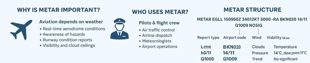
Why METAR Is Important for Aviation
Aviation operations are highly weather-dependent. Every single operational decision—takeoff, landing, alternate planning, fuel calculations, approach category, and even passenger handling—depends on accurate and timely weather reports. METAR provides essential data like wind, visibility, cloud ceilings, pressure, and significant weather.
For example:
- Low clouds or fog can affect landing CATEGORY II/III operations
- Strong crosswinds may exceed aircraft or runway limits
- Thunderstorms influence taxi, takeoff delays, or diversions
- Rapid pressure changes affect altimeter settings
In short, METAR helps pilots understand exactly what conditions they’re flying into and enables ATC and Flight dispatcher to maintain safe and efficient airport operations.
Who Uses METAR?
Pilots are not only the users of METAR but, it is also critical for several other aviation stakeholders. Following is the list and purpose for METAR users.
- Pilots: Use for Selecting runways, Approach planning, Alternate airport decisions, Fuel calculation, Taxi and takeoff planning
- Air Traffic Controllers: Use to determine runway in use, Activate low visibility procedures, Adjust arrival and departure spacing, Broadcast ATIS
- Airline Dispatchers & Operations Centers: Strategic flight planning, Route adjustments, Diversion management, Weather monitoring across the network
- Meteorologists: To verify observations, calibrate models, and issue SIGMETs and TAFs.
- Flight Training & General Aviation: Student Pilot and private pilots rely heavily on METAR for VFR/IFR planning.
METAR Structure
As mentioned above METARs follow a standard defined fixed, coded format as per ICAO Annex 3. METAR codes are intentionally compact but convey rich information. Here’s a sample
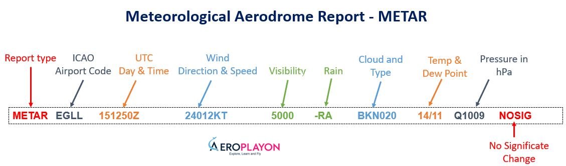
Breaking down the structure:
- METAR – Report type
- EGLL – ICAO airport code (London Heathrow)
- 151250Z – Day 15, time 12:50 UTC
- 24012KT – Wind from 240° at 12 knots
- 5000 – 5 km visibility
- -RA – Light rain
- BKN020 – Broken cloud at 2,000 ft
- 14/11 – Temperature 14°C, dew point 11°C
- Q1009 – Pressure 1009 hPa
- NOSIG – No significant change expected
How to Decode METAR: A Practical Example
Let’s decode a slightly more complex METAR to see how pilots interpret it:
METAR KLAX 121553Z 26010KT 3SM HZ OVC008 19/16 A2997 TEMPO 2SM BR
Decoded in plain language:
- KLAX – Los Angeles International Airport
- 121553Z – 12th day, 15:53 UTC
- 26010KT – Wind 260° at 10 knots
- 3SM – 3 statute miles visibility
- HZ – Haze
- OVC008 – Overcast cloud layer at 800 ft
- 19/16 – Temperature +19°C, dew point +16°C
- A2997 – Pressure 29.97 inHg (U.S. format)
- TEMPO 2SM BR – Temporary drop to 2 miles visibility due to mist
This METAR tells pilots that low ceilings and reduced visibility are present—critical information for Instrument Flight Rule (IFR) arrivals into LAX.
How METAR Is Transmitted to Pilots
Pilots receive METAR through several communication channels, both on the ground and in the air.
- ATIS (Automatic Terminal Information Service): Broadcasts the latest METAR-based information on a dedicated VHF frequency before departure and approach.
- D-ATIS (Digital ATIS): The same ATIS data delivered electronically through datalink (ACARS), displayed directly on cockpit screens or EFBs.
- ACARS (Aircraft Communications Addressing and Reporting System): The most common method in flight. Pilots can request: METAR, TAF SIGMET, Wind/temperature data, This is especially important on long-haul flights.
- VOLMET (VHF and HF): Continuous broadcasts of METAR, SPECI, and TAF for major airports in a region—useful en route or on oceanic sectors.
- ATC (Tower, Approach, and En-Route Controllers): Controllers may directly pass updated weather to pilots during rapidly changing conditions.
- Flight Dispatcher & EFB Apps: Before departure, dispatch sends a complete weather package including METARs, TAFs, and NOTAMs. Many pilots also check this on their EFB (e.g., Jeppesen, ForeFlight).
METAR and TAF Difference
. Pilots use both together for a complete weather picture.
METAR and TAF are two essential aviation weather reports people often mix up. They are different and serve different purposes for pilots, air traffic controllers, and flight planners.
METAR = actual weather now; TAF = predicted weather ahead.
- A METAR is a current weather observation. It provides real-time conditions at an airport, typically issued every 30 or 60 minutes. METAR includes details such as wind speed and direction, visibility, temperature, dew point, cloud cover, runway visual range, and significant weather events like rain, thunderstorms, or fog. Because it reflects the actual, observed situation, pilots use METAR during pre-flight checks, approach, and landing to understand what is happening right now.
- A TAF (Terminal Aerodrome Forecast), on the other hand, is a forecast of expected weather conditions at an airport. It is issued four times daily and usually covers a period of 24 to 30 hours. TAF predicts changes in visibility, wind, clouds, and phenomena like storms or low-level wind shear. Instead of momentary conditions, it describes how the weather will evolve. Pilots and dispatchers use TAFs for fuel planning, alternate airport selection, and assessing flight feasibility over the next several hours.
Who Provides or Generates METAR?
METARs are produced by a combination of national meteorological authorities, airport weather offices, and automated systems, regulated by ICAO and WMO.
Key Providers Worldwide:
- USA: NOAA / NWS / FAA (ASOS systems)
- Europe: MET Office (UK), DWD (Germany), Météo-France, AEMET, KNMI
- India: India Meteorological Department (IMD) + Airports Authority of India (AAI)
- Canada: NAV CANADA & ECCC
- Australia: Bureau of Meteorology (BOM)
- Japan: JMA
- China: CMA
- Middle East & Africa: National meteorological authorities
- Military aviation: Dedicated weather units (USAF, RAF, IAF, etc.)
These agencies ensure that METARs are accurate, standardized, and updated around the clock.
Final Words
METAR may look like a string of cryptic characters, but inside that compact format lies the most essential real-time weather information for aviation. It keeps pilots safe, airports efficient, and global operations synchronized. From automated sensors on the runway to international aviation networks that deliver the report into a pilot’s cockpit, METAR remains the backbone of aerodrome weather reporting.